
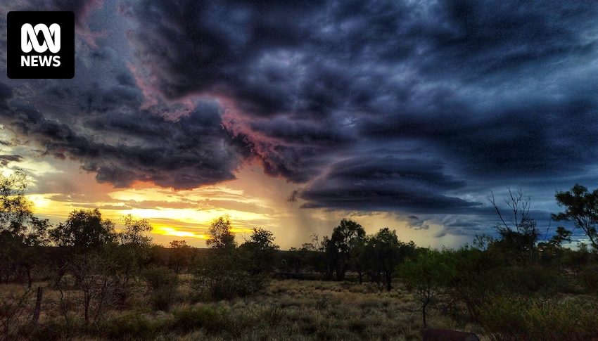

An invasion of humid air from the north will generate widespread heavy rain across northern Australia during the coming fortnight.
The increased tropical activity has already soaked Queensland this week, including 301 millimetres in Townsville in the 24 hours to 9am on Wednesday, the city’s heaviest fall since January 1998.
The NT and WA’s Kimberley are also likely to see enhanced rain into the weekend as the monsoon trough possibly returns to our longitudes — a pattern also conducive to the formation of tropical lows and cyclones.
The current burst of increased tropical activity could last for weeks, ensuring above average rain this wet season for most of the tropics, along with potentially one of the most active cyclone seasons this century.
Cyclone possible off WA coast from the weekend
The monsoon trough is an elongated belt of converging moist winds and is responsible for spawning the majority of tropical cyclones in the Australian region.
The return of the monsoon this week over the northern Indian Ocean has already caused a developing tropical low just south of the Cocos Islands.
While the system poses no threat to Australia’s mainland, another tropical low is likely to form by Friday closer to WA.
Initially the low will develop more than 500 kilometres offshore, however the general consensus is a movement slowly towards the coast during the coming days, travelling over water temperatures in excess of 31 degrees Celsius.
Considering the threshold for cyclone formation is 26.5C, further development into a tropical cyclone is possible as it nears the Pilbara or Kimberley coast this weekend.
The potential for another cyclone continues a busy season relative to recent years, with the Bureau of Meteorology (BOM) confirming nine tropical cyclones since December, the highest number in three years and just two below the long-term season average of 11.
This season’s tally included five tropical cyclones in February alone, the most since January 2011.
If the WA low does reach cyclone strength, its name will be declared Courtney or Dianne (depending on the status of the Cocos Islands system), following the alphabetical sequence after Alfred and Bianca.
However, according to the BOM’s tropical cyclone forecast, the system has only a 10 per cent chance of intensifying this weekend, ahead of a slight increase in risk early next week.
This is supported by the ECMWF, one of the world’s leading weather models, which currently predicts a gradual increase in cyclone probability, reaching a peak of about 30 per cent off the Pilbara coast from Monday to Wednesday.
So what is Dianne or Courtney’s most likely destination?
Later in the week, modelling continues to favour a position offshore and a track towards the west — so moving roughly parallel to the Pilbara coast, however as we saw during Alfred, cyclone forecasting is notoriously difficult and it would be far too early to discount a coastal crossing.
Flooding rains drench NT and Queensland
The rest of Australia’s north and central interior is also seeing increased rain this week as humid air moves inland from the equatorial waters off our northern coastline.
Over the past week, more than 500mm has drenched parts of the North Tropical Coast and Lower Burdekin, including 872mm at Garradunga in the Johnstone catchment.
The deluge has triggered flooding along multiple rivers, including a brief major flood warning on the Bohle River on Wednesday.
While the heaviest rain this week has fallen near the coast, rain on Wednesday also spread to the inland parts of northern Queensland, including up to 85mm in the 24 hours to 9am across the Northern Goldfields.
Further west, the incoming tropical moisture is causing cloud to build over the central outback — finally ending weeks of sunshine where maximums have climbed above 40C on most days.
By the weekend showers and thunderstorms should spread to all corners of the NT, along with neighbouring parts of northern SA.
Heavy rain should then persist next week across much of northern Australia, with areas of flooding possible, especially if the monsoon becomes established over the mainland.
The daily dose of rain will accumulate to significant weekly totals, with an average fall in excess of 100mm likely for the Kimberley, central and northern NT, and across the northern tropics of Queensland.
Wet weather on the horizon long-term
Heavy rainfall in March is likely to continue into early April over northern Australia.
Longer range modelling is indicating the abundant rain during the next week or two is likely to linger into early April.
The BOM’s two-week forecast covering the period from March 30 to April 12 shows up to an 80 per cent chance of above median falls for parts of northern Australia.
The monthly forecast for April also favours wetter than average conditions, which implies cyclone activity is also likely to be enhanced for the remainder of the wet season.
Another three named storms this autumn would take the tally to 12 — enough to become the busiest Australian cyclone season in 19 years.


